Along the Govilon Line
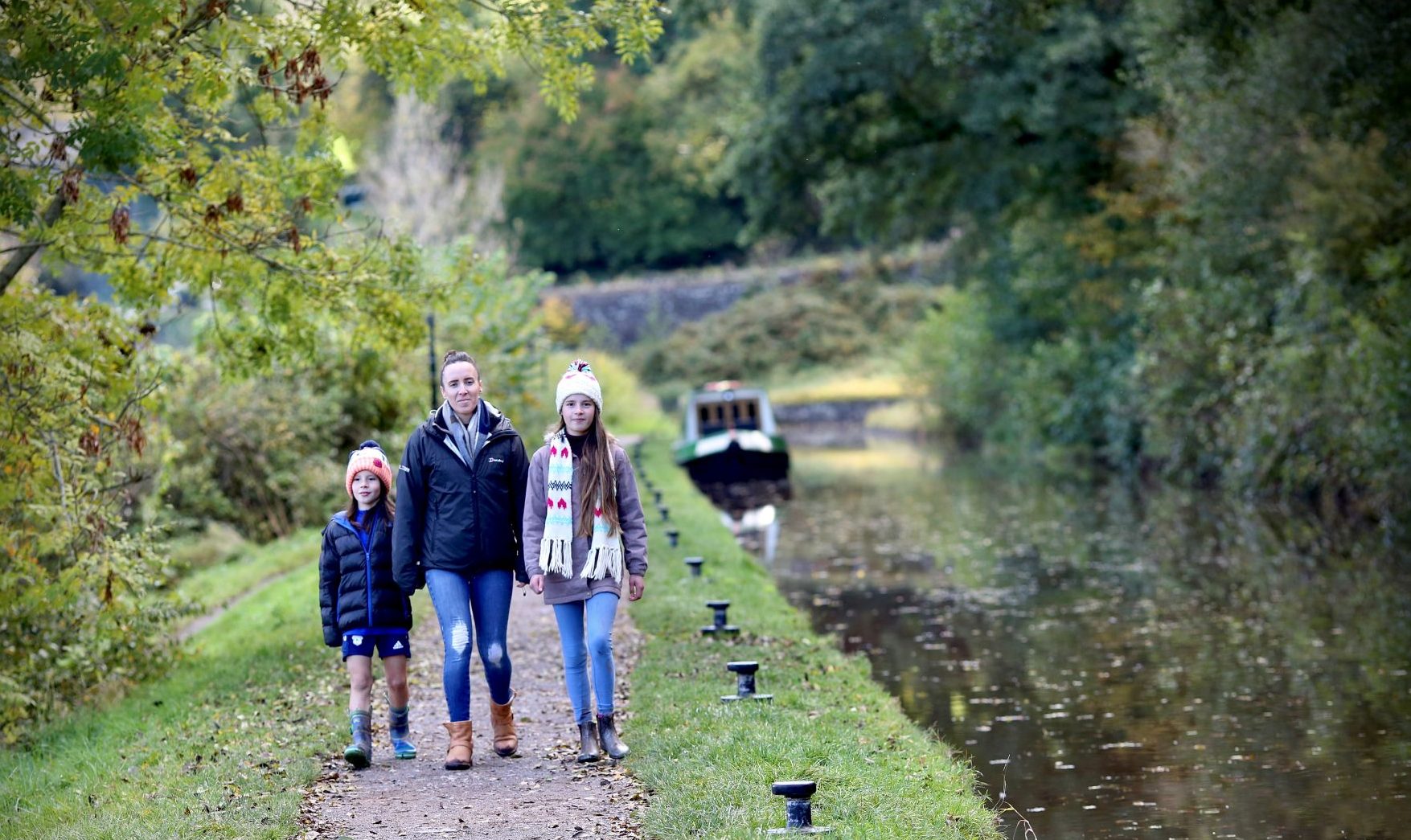
Along the Govilon Line – walk between two canal side villages along the route of the old railway line.
An amble between two canal side villages along the former railway which runs below The Blorenge’s verdant wooded slopes.
The route offers a contrast to Abergavenny town, providing an opportunity to enjoy the area’s natural and industrial heritage.
This is a grade 1 walk – routes which are barrier free, have negligible gradients and solid or compacted surfaces and seats.
Of interest
You will be following the route of the old Merthyr, Tredegar and Abergavenny railway line through cuttings and along embankments, enjoying views over the surrounding countryside in the Bannau Brycheiniog/Brecon Beacons National Park.
On a nice day you can savour the dappled sunlight as it plays on the path through the branches of the birch and willow trees. You may see a wren or other wildlife foraging for food amongst the array of shade loving plants which decorate parts of your route.
Listen out also for the tinkling of a bicycle bell warning you that a cyclist is approaching. This may be the modern equivalent of the old steam whistles which the trains used to blow as they strained their way up towards Brynmawr – a gentle gradient for you but quite a challenge for a train!
You can spot the many features which hark back to the days of steam; mileposts, gradient signs and lineside buildings such as the old Govilon Station.
Watch for passing cyclists; route 46 of the National Cycle Network is also on the route.
Grade 1
Easy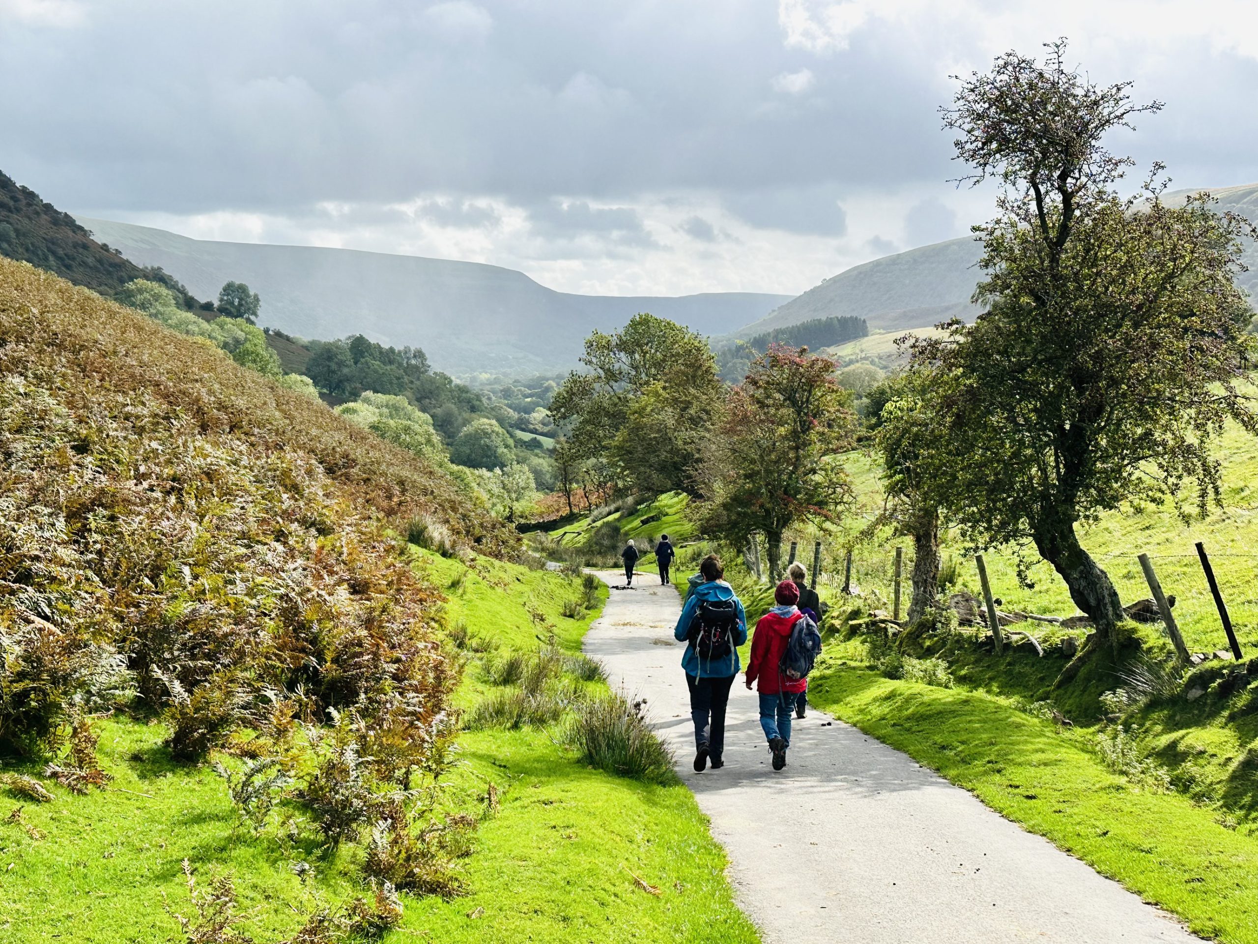
Where would you like to go next?

Llangynidr to Storey Arms (Beacons Way -day 4)
Llangynidr to Storey Arms (Beacons Way – day 4) The most strenuous day, but you will be rewarded by spectacular views.
Start point: Llangynidr (SO 152201)
Finish point: Storey Arms (SN 982203)
Distance: 23.5km / 14.5 miles
Ascent: 1110m / 3640ft
Difficulty: Strenuous
Time: 7 hours
Facilities at startpoint: Cafe, Car Park, Toilets
Once at the summit you follow the edge of the escarpment to a waterfall that plunges over the edge. In winter the water freezes to form icicles. It is worth the short diversion to Fan y Big where you can stand on the ‘Diving Board’, a rock that juts out on which you can stand. After descending to the ‘Gap Road’ there is another stiff climb to Pen y Fan. At 886m it is the highest peak in southern Britain.
Directions:
This is a stunning day over the most spectacular part of the Beacons. It’s a gem, but be prepared – it is long and you climb high! Leave Llangynidr along the canal to the west, cross the footbridge by the lock and head up-hill though woods and fields to a lane. Head left along this, then turn off right onto a track that leads steadily uphill through a farm to the top of the ridge with great view over Talybont reservoir.
Take the wide track to the left around the side of the hill and along the ridge before dropping down to the right into the forest and so joining the Taff Trail. As you head up to the road look out for the waterfalls on the other side of the valley.
At the car park follow the steep path up past more waterfalls, pausing frequently to admire the views, and along the steep edge of Craig y Fan Ddu. At the stream crossing, turn left on the less obvious path to the pile of stones, then across the hill and along the equally steep escarpment edge to Fan y Big with its iconic ‘Diving Board’ hanging above the valley, scene of many photos.
Heading left and steeply down to the ‘Gap Road’, you miss the climb to Cribyn by going round on its left but the spectacular climb up to Pen y Fan will test your legs. Follow the major path down from the summit but fork right for great views from Corn Du. From here, head south and steeply down to the National Trust’s surfaced path leading to Pont ar Daf Car Park on the A470. A footpath at the far end takes you to the roadside at Storey Arms (now an Education Centre) and the halfway point of the Beacons Way.
Although the Youth Hostel is close by, this can be full so you may need a bus or taxi to get to your accommodation.
Grade 5
Very very challengingWhere would you like to go next?
Storey Arms to Craig-y-Nos (Beacons Way -Day 5)
Storey Arms to Craig-y-Nos (Beacons Way – day 5) Your journey to the West of the Bannau Brycheiniog (Brecon Beacons) begins today.
Start Point: Storey Arms
Finish point: Craig y nos
Distance: 23.5 km / 14.5 miles
Ascent: 610m / 2000ft
Difficulty: Moderate
Time: 6 hours
Day five starts your journey into the western Bannau Brycheiniog (Brecon Beacons) . You will notice the area is quieter and you may event have the hills to yourself. The route initially follows high above the A40, crossing streams and waterfalls before you venture onto the open hill.
Buzzards and Peregrine Falcons soar above and ponies can be seen grazing. A fine example of heather moorland is traversed before entering Ogof Ffynnon Ddu National Nature Reserve. It has been designated to protect its limestone pavements, associated flora and caves beneath.
Directions:
You are now leaving the well-trodden paths of the eastern National Park. From now on it is wilder, more isolated and there are fewer people around.
Leave the Storey Arms layby at its western corner, following the path along the high edge of Craig y Fro and so to the wall above Craig Cerrig-gleisiad National Nature Reserve. Follow the wall left to a corner, then left a short distance before heading up an indistinct path to a pile of stones after which it drops to eroded ground and ascends the fine ridge of Fan Dringarth and Fan Llia.
If mist makes navigation difficult here, drop west to the Roman Road and follow the minor road south. The path diminishes as you head downhill from Fan Llia – pick your way through the rushes and streams to a stile. Then cross the footbridge by the forestry car park and head up to the road. Turn right 250m to reach a track cutting back sharply on the left. This is Sarn Helen, a Roman road that takes you past Maen Madoc, a superb standing stone marking an early Christian burial, into the next valley. Cross the footbridge over the Nedd Fechan and head up the track that leads you once more onto the open hill. Turn right here and follow the track across the moor for 500m before turning distinctly left. Pass some old buildings on the right, then cross the stile into the Ogof Ffynnon Ddu National Nature Reserve, famous for the major cave system beneath your feet and its rare limestone pavement.
Descend through the Nature Reserve, past old quarries and tram-road routes, emerging north of the South Wales Caving Club.
Follow the track right and then left onto the tarmac road at the quarry entrance. After 200m take the path on the right, into Brecknock Wildlife Trust’s Nature Reserve and down to a track leading you into the back of Craig-y-nos Country Park. Accommodation and pubs are nearby but not all are within easy walking distance – you may need to use the bus or a taxi.
Grade 4
Very challenging
Where would you like to go next?
Craig-y-Nos to Llanddeusant (Beacons Way – day 6)
Craig-y-Nos to Llanddeusant (Beacons Way – day 6) Day six starts from Craig y nos Country Park, once owned by the opera singer Dame Adelina Patti. The route takes you to Llyn y Fan Fawr, the highest natural lake in south Wales. Chose between the good or poor weather routes based on the forecast for the day.
Good weather choice:
(Scroll down for poor weather choice, but note there is a variation you can choose if the weather changes, after you have already begun the good weather option).
Start point: Craig-y-nos Country Park (SN 840155)
Finish point: Llanddeusant (SN 776245)
Distance: 16km / 10 miles
Ascent: 760m / 2500ft
Difficulty: Hard
Time: 5 hours
Day six starts from Craig y nos Country Park, once owned by the opera singer Dame Adelina Patti. The route takes you to Llyn y Fan Fawr, the highest natural lake in south Wales. A short, steep ascent takes you above the lake and onto Fan Brycheiniog, the highest point in the western Brecon Beacons at 820m. From here you can see Llyn y Fan Fawr nestling in the bottom of the escarpment and, on a clear day, you can see Pen y Fan in the east and the Bristol Channel and Somerset/Devon coast in the south. Another short, steep climb to the summit of Bannau Sir Gaer rewards you with views of Llyn y Fan Fach.
Good Weather Directions:
Starting from Craig-y-nos Country Park, follow the bridleway north towards Pwllcoediog Farm but turn left onto a footpath to pass to its west. Turn left at the road, right at the Outdoor Centre, then across fields to the main road and the Tafarn y Garreg pub. Carefully cross the fast road and take the path to the left of the car park to the footbridge, passing east and north of Ty Hendry.
If the weather has turned poor during your walk, particularly in high winds, consider taking the variant path north from here.
From here, ascend to Allt Fach. There are numerous, potentially confusing, sheep tracks on the way so you may want to follow a compass bearing. Follow the obvious ridge of Fan Hir to Fan Brycheiniog and Fan Foel, with huge views into the Beacons and Mid Wales above the steep slopes. If conditions deteriorate, you can leave the ridge at Bwlch Giedd and follow the variant to Llanddeusant. Continue west, high above the cwm of sparking Llyn y Fan Fach, before following the path north off the Hill.
Cross the footbridge and then turn left onto the road to the Youth Hostel. This is the only accommodation or place to eat within walking distance so you may need a taxi if it is full.
According to the Mabinogion, a farmer married a beautiful woman with magical powers who he met sitting on rocks near Llyn y Fan Fach. Their sons became the famous Physicians of Myddfai – the village nearby. Some believe that this myth gave rise to another famous tale – the Arthurian legend of the Lady of the Lake and Excalibur.
In the event of poor weather (particularly strong winds), day 6 can be difficult and dangerous, so please take this poor weather alternative.
Poor Weather option Craig-y-Nos to Llanddeusant
Start point: Craig y nos (SN 840155)
Finish point: Llanddeusant (SN 776245)
Distance: 16.5km / 10.5 miles
Ascent: 550m / 1800ft
Time: 4 hours 45 mins
Difficulty: Moderate
In the event of poor weather (particularly strong winds), day 6 can be difficult & dangerous, if so please follow this poor weather alternative.
From Ty Hendry, follow the contours north, keeping the steep ground on your left and crossing the stream near the waterfalls. When you reach Llyn y Fan Fawr, walk along its eastern side but then return to the base of the hill and round the base of Fan Foel and Picws Du. Follow the small stream north west to the dam diverting its flow into Llyn y Fan Fach. Head west to the Llyn (formerly a water supply reservoir) and then north down the obvious track which, after turning into a public road, joins the main route to Llanddeusant.
Grade 5
Very very challengingWhere would you like to go next?
Penwyllt Circuit
Penwyllt Circuit – extensive views in the less visited South West of the Bannau Brycheiniog (Brecon Beacons) Park, you look down the Upper Swansea Valley and beyond as you follow old railway lines and tramroads.
This enjoyable, circular walk takes you through a fascinating area full of remains from its industrial past in the South West of the Bannau Brycheiniog (Brecon Beacons) National Park.
This is a grade 3 walk – routes with occasional long gradients, a solid but undulating surface in places and kissing gates or stiles. There are no seats.
Of interest
As you start out from Penwyllt – ‘the wild end’ in Welsh – it is difficult to imagine that this quiet former quarrying village was a major production centre for quicklime and brick in the 19th and early 20th centuries.
The five limestone quarries and brickworks which operated here between the 1870s and 1950s must have been quite a sight and made quite a din.
Along part of the route you will be following the old Neath and Brecon Railway line where you may still detect buried sleepers.
You will spot several piles of stone which hint at this industrial past, including the remains of the old winding house.
Grade 3
Challenging
Where would you like to go next?
Carreg Cennen Castle to Bethlehem (Beacons Way – day 8)
Carreg Cennen Castle to Bethlehem (Beacons Way – day 8) Day eight is short and the least demanding – appropriate for the last day.
Carreg Cennen Castle to Bethlehem – Beacons Way – day 8
Start point: Carreg Cennen Castle (SN 666193)
Finish point: Llangadog railway station (SN 699286)
Distance: 16km / 10 miles
Ascent: 280m / 920ft
Difficulty: Easy
Time: 4 hours
Day eight is short and the least demanding – appropriate for the last day.
The route passes through the middle of the ruined walls of Y Gaer Fawr , which date from 300BC. It is Wales’ second largest Iron Age hillfort. The route comes to a conclusion in the village of Bethlehem, renowned for its Post Office, which is now a private house. However a part-time Post Office is housed in the former village school. This is a hive of activity as Christmas approaches, when people want their Christmas cards to carry the village’s postmark.
Directions:
From Carreg Cennen car park, head along the road until Castle View, then turn north along the obvious track. The track continues in a north-easterly direction until it changes to a path north of Cilmaenllwyd. Follow the markers through the fields until it rejoins the road – follow this for about 1.5km to the cross roads where you head straight on and cross the stile on your right. The clearly marked path heads through the fields and into Carreglwyd Forest, descending then re-ascending east through the trees to Bwlch y Gors. From here descend again through the fields along a track.
Join a road at Garn Wen, then head north and west at the track junction up to Garn Goch, an iron age hill fort with magnificent views over the Towy Valley on one side and up to the mountains on the other. Its prominent position led to it being occupied since ancient times – at least since the Bronze Age. Descend west through Y Gaer Fach (another hill fort) to the car park.
From the car park turn right at the road then after about 1km turn left onto a path immediately after the chapel and so into the village of Bethlehem.
Please take care as the lanes in this area are very narrow.
From Bethlehem, head north east on the road towards Llangadog, then after 800 metres, take the signed bridleway down to the left just before some houses. The route continues across paths, tracks and roads to wind its way pleasantly down to Felindre and across the bridge and through the beautiful Sawdde Common to Llangadog, reaching the A4069 opposite the Church. Mountains are visible in the distance and this marks the end of the magnificent journey Turn left on the main road, continuing on to Llangadog Railway Station and the end of the Beacons Way route. There is accommodation, shops and places to eat in Llangadog or you can catch trains up or down the line.
Grade 3
Challenging
Where would you like to go next?
Crickhowell to Llangynidr (Beacons Way – day 3)
Crickhowell to Llangynidr (Beacons Way – day three) is less arduous than the previous two days.
Start point: Crickhowell (SO 215189)
Finish point: Llangynidr (SO 152201)
Distance: 19 km / 12 miles
Ascent: 750m / 2460ft
Difficulty: Moderate
Time: 5 hours 30 minutes
Facilities at start point: Pub, Cafe, Car Park, Restaurant, Accommodation, Bus Stop, National Park Information, Shop, Toilets, Post Office
Day three is less arduous than the previous two. The climb out of Crickhowell and onto the edge of Pen Cerrig-calch is gentle. Although the route here is not particularly elevated, the views of the meandering River Usk and the rural landscape are very pleasing.
You will descend to Cwmdu village and up to Blaen-y-cwm along narrow, quiet lanes before climbing once again onto Cefn Moel and the open hill. Here you will see Llangorse Lake below you. It was formed in the Ice Age and is entirely natural. It is a Site of Special Scientific Interest as one of the few lakes in Wales which is naturally rich in nutrients and is of national if not international importance.
The day can be finished either at Bwlch or Llangynidr, where the route crosses a splendid, ancient, narrow bridge.
Directions:
Leave Crickhowell by the lane on the north-western edge of town that follows the stream up from the ornate bus shelter. Head past one farm and along tracks to the next (avoiding it through fields on the right). Continue to follow a walled track to the left, up between the fields to reach the open hill.
The route now winds its way along the side of the hill, around Cwm Mawr (where you can find John Sansom’s memorial stone) before heading down to the village of Cwm Du via farm tracks and country lanes. The village is today’s halfway point and boasts both a café and pub to help you refresh and refuel.
Carefully cross the main road by the pub and follow the lane opposite a short distance, then use the path to cut up through the fields to the next lane. This is followed uphill before taking a path onto the open hill at the second farm. This leads steeply to the top of Cefn Moel with great views over the magnificent Llangorse Lake. From here, you can follow obvious tracks along the ridge to the left that lead you down into Bwlch which has pubs and accommodation.
Carefully cross the busy main road and follow the lane at the side of the pub, then the path on the left that leads through fields to the road junction. The road to the right takes you down to and across the ancient road bridge – one of the best in Wales – into Llangynidr which has two pubs but limited accommodation. The bus or a taxi can easily take you to Talybont on Usk where there is much more available.
Grade 3
Challenging
Where would you like to go next?
Crickhowell to Table Mountain
A short but steep walk up the mountain to admire the views from the hillfort which crowns it.
Get your pulse pounding as you walk through some wonderful countryside, the breathtaking views from the top make the climb worthwhile. This walk offers a short, sharp ascent of 380m to the flat topped Table Mountain above Crickhowell, named after the Iron Age hillfort called Crug Hywel – Hywel’s fort in English. A popular town in the Bannau Brycheiniog/Brecon Beacons National Park.
This is a grade 4 route: Routes with narrow sections, steep gradients or muddy and stony surfaces. Gates are narrow or there are stiles. There are no seats.
Of interest
From Crickhowell, Table Mountain looks as if it slopes at a slightly tipsy angle but from the top you’ll be able to look back at the stylish town on the site of an ancient crossing point over the River Usk.
After following a tree lined path up beside Cumbeth Brook you will emerge onto open hillside. The town will be a distant memory as you make your way along the mountain wall to the back of the hillfort which crowns the mountain. It is this Iron Age hillfort called Crug Hywel – Hywel’s fort in English – which gives the town below its name. Once you arrive you’ll see extensive remains of this ancient stronghold in the form of ditches and ruined stone defences. Beneath you stretches the broad-bottomed Usk Valley whose far side rises towards Mynydd Llangatwg and beyond to the industrial valleys of South Wales. Meanwhile the brooding Mynedd Du/Black Mountains loom over your shoulder o the north.
Grade 4
Very challenging
Where would you like to go next?
Brecon Prom
Brecon Prom – an ideal walk if you are visiting Brecon and want to walk by the river from the town centre.
This is an ideal walk for you if you’re visiting Brecon for a saunter around town and fancy a walk beside the River.
There’s nothing better than strolling along this riverside promenade to experience the river Usk in all its glory.
Sometimes you can spot kingfishers and dippers.
The Promenade is popular with families for walking, picnics and dog walking. There are surfaced riverside paths, a large meadow, views of the Beacons and a children’s play area. A flat tarmac path with seating, runs alongside the River Usk for approx. 1/2 miles/800m from the entrance at Watergate bridge to the meadow. If approaching from the town end, it is necessary to cross a short, but steep, flood embankment from the car park, near Watergate bridge. This section can get flooded after heavy rain.
An alternative route is along Kensington. Again, there is a short steep flood embankment by the bowling club. After passing the weir, the path splits. The left fork slopes down, the right fork is level, then slopes down. Further upriver from the Promenade car park there is a flat surfaced circular path with benches and grassy meadows. A further ¼ mile/400m through the meadows is accessible to walkers via narrow kissing gates. The path continues, but stops being easily accessible, becoming narrow, steep in places, and uneven with compacted soil and grass and exposed tree roots in places.
This route is a grade 2 walk – a route with tarmac surface, some sections with slight gradients but no gates. There are plenty of seats along the way.
Of interest
You’ll experience the river in one of its many moods: anything from dreamily flowing along at a low level to a raging chocolate coloured torrent (brown with mud stirred up by it’s passage). Fish abound in the river Usk’s waters feeding kingfishers, cormorants and mallard and goosander ducks. Look out for the blue flash of the kingfisher as it darts along the river, or you may spot cormorants perched near the weir drying themselves after diving for fish under the water.
Llanfaes Bridge with its seven arches which was originally built in 1563 but has been much modified since, previously you would have had to wade across river via a ford near this point before the bridge was built.
Public Transport: Buses from Swansea, Cardiff, Abergavenny and Hereford (TC) to Brecon Interchange approx.0.75 miles (1.2km) away. To access the Promenade take no. 40 town bus (TC) to Cradoc Rd and there is a 5 min walk from there along Fenni Fach Rd. Be aware some stretches have no pavement.
Parking: Pay and Display car parks at the Promenade (the furthest car park is nearest the toilets) and at Kensington car park, all with disabled parking bays.
Nearest EV Charging: Morrisons Brecon, Free Street, LD3 7SE
Facilities: There is a café and boat hire at the Promenade car park. There is a kiosk café at by the Kensington car park with outside seating. Both open late spring to autumn.
Toilets: Toilets, including a disabled toilet (RADAR) can be found at the main public toilet block at the Upper Meadow car park.
Grade 2
ModerateWhere would you like to go next?
Keepers Pond to Blorenge
Circular walk offering extensive views across the Bannau Brycheiniog/Brecon Beacons National Park. Admire Usk Valley and climb the Blorenge mountain.
This Circular walk offers extensive views across the Bannau Brycheiniog/Brecon Beacons National Park. You can admire Usk Valley towards the Sugar Loaf and the Black Mountains, watch dragonflies and birds on the pond and climb up the Blorenge.
This is a grade 3 walk: Routes with occasional long or steep gradients, a narrow path in places, poor surfaces and kissing gates or stiles. There may be no seats.
Of interest
Keepers Pond, known as Pwll Pen-ffordd-goch – pool of the head of the red road in Welsh, was built in the early 19th century to provide water for Garnddyrys Forge. Its original purpose came to an end when the forge was dismantled in the 1860s but the pond then became a beauty spot.
As you wind your way across the heather-clad moorland on the Blorenge, spare a thought for the gamekeeper who lived in a cottage nearby and who gave the pond the English version of its name. Although the epitome of tranquillity today, the area would have resounded to the sound of horse-drawn trams during the area’s industrial heyday and so it now falls within the Blaenavon World Heritage Site.
Bear in mind – the name Blorenge may come from the old Saxon word ‘blore’ which means wind – it’s best to come prepared.
Grade 3
Challenging